The T4E Mapping App ready for downloading!
Yet another app for forestry management – why is it needed?
Another innovative result and product of the TECH4EFFECT project is the Mapping App developed by the University of Göttingen and Latschbacher GmbH.
Currently, remote analysis relies on large quantities of information, which can be generated from easily accessible data sources, such as aerial and satellite-based LiDAR imagery, partially available from public services. This information can contribute significantly to improve forest management, in particular planning and carrying out of forest operations.
Of special relevance to Work Package 4 – “Site Impact” is an improved decision basis to enable mitigation of forest soil disturbances caused by heavy forest machinery. But, one of the biggest challenges to operationalise the data is visualisation in the field.
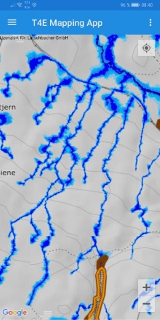
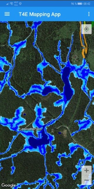
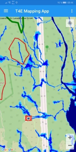
Fig. 1: Example of three different Base Map Layers of the Mapping App ((c) Google Store/Mapping App)
The increased knowledge of sensitive spots within a forest stand (trafficability maps) can support the mitigation of heavy impacts, e. g. deep ruts. Existing mappings of these sensitive spots are not in every-day use, since their information is too specific or maps are not implemented in on-board computers of forest machines – it cannot be expected of a machine operator or forest worker to manually edit and provide accurate feedback to operations managers in analogue format.
The Mapping App (see Fig. 1+2) enables an exchange of information across different interested parties involved in given forest operations and in addition combines soil trafficability maps, with already available maps like road maps, forest inventory maps etc.) and makes it available across platforms.
The T4E Mapping App
The T4E Mapping App is a handy tool that allows field operatives access to the most recent, complete and diverse data available. The basic data includes terrain trafficability quantified through a Depth-To-Water map (DTW map; refer to Deliverable D4.1, woodland key habitats and other hotspots requiring special awareness, as well as terrain or slope maps.
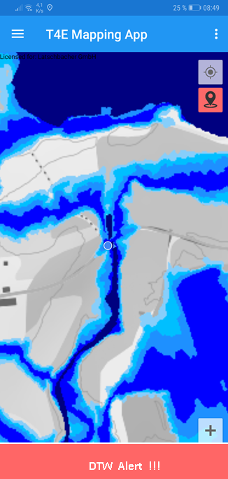
Fig. 2: The Mapping App gives a visual and audio alert if machine operators access a critical terrain ((c) Google Store/Mapping App)
The position of the forest machine or worker using the device is always indicated in relation to other features on the map. As Web Map Service is used, any data layers from any participating country can be displayed. A number of key functions are employed in ensuring full versatility of the tool:
- The app user can annotate the map with text and vector features including polygons, lines, and points, with the option of activating a track log recording the machine or user’s movements. Additionally, the user can be warned when approaching a critical area in terms of low predicted soil bearing capacity (DTW maps) by a pushing notification.
- The maps can be cached and map tiles can therefore be used offline in areas with poor network coverage. The user is able to store locally or share the annotations, as well as geo-referenced photographs, with other actors via a number of technologies (FTP, OneDrive, and Dropbox).
Technically, it is now possible for the user to add environmental data to the SILVISMART database. This provides an innovative new approach to capturing and working with environmental considerations within the efficiency framework being developed within the TECH4EFFECT project as a whole.
Contacts
University of Göttingen, Germany
Latschbacher GmbH, Austria

Downloads
- Mapping App in Google Play Store
- Public Deliverable D4.3 on the Mapping App
- Public Deliverable D4.1 “Terrain Accessibility Maps for 4 case study areas”
- Mapping App Manual in English (coming soon!)
- Mapping App Factsheet (coming soon!)
- Presentation of the Mapping App (coming soon!)
Events
 TECH4EFFECT final event highlights research impacts, provides informed dialogue on forest operations19. July 2021 - 12:25
 Towards Zero Pollution: TECH4EFFECT presented at the RTDS Green Week Partner Event on 8 June: 10:10 – 12:30.10. May 2021 - 16:18
 TECH4EFFECT Co-ordinator, Rasmus Astrup, presented at EUBCE event19. April 2021 - 15:17
 TECH4EFFECT presents drone mapping, T-winch at Norwegian Ministerial event14. October 2020 - 9:15